Monday, July 24, 2017
Tuesday, July 18, 2017
USDA Web Soil Survey
This was my 1st experience with the USDA Web Soil Survey and for someone who is practically computer illiterate, I must say this was a fun, easy, and highly educational process.....one which I will continue to explore and utilize. In fear of losing the work I was doing, I took frequent screenshots posted below.
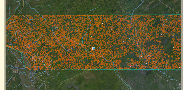
The process begins with describing an Area of Interest (AOI), which I decided upon the northern approximate 78,000 acres within the Apalachicola National Forest of Wakulla County, FL. For reference, below is a screenshot showing the AOI in northern Florida along the Gulf of Mexico. (NOTE: I did not intend to include any acreage outside of Wakulla County, however, when I drew my polygon, I mistakenly included 740 acres and 698 acres within neighboring Liberty and Leon Counties, respectively. Also, AOI's are limited to 100,000 acres or less.)

Once an AOI is defined, I was able to create soils maps by clicking on the Soil Map tab. Various soil types are identified within the AOI, along with their acres and percentages.

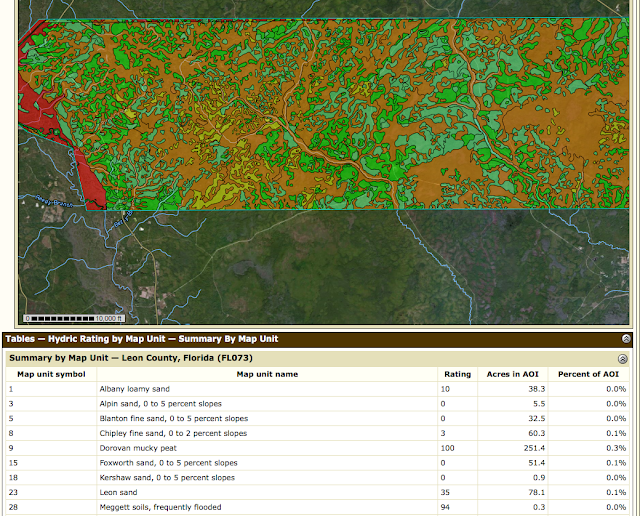
Various maps can then be created by selecting the Soil Data Explorer tab and selecting a variety of parameters by working through various options/tabs. As this was my 1st experience doing this, I kept it simple and created a map showing the Hydric Rating by Map Unit within the AOI (see below).

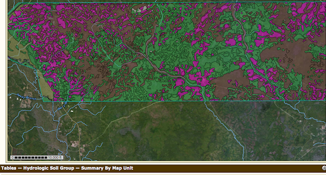
.....followed by Hydrologic Soil Groups

Since I am particularly interested in the Longleaf Pine Ecosystem, by clicking on the Ecological Site Assessment tab I was able to create a map identifying the dominant ecological site for each map unit, with each soil component being associated with an ecological site.
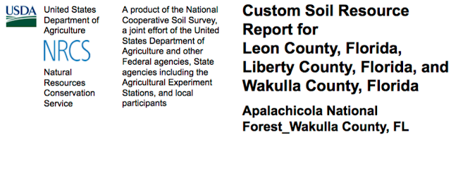
To my amazement, I was then able to generate a custom report by clicking on the Soils Report tab.....I did not realize I was so smart!!

In all seriousness, I've always been intimidated by those who could generate this type of data/maps/reports and dismissed consideration that I could ever do the same. I am looking forward to utilizing this FREE resource in the future and encourage anyone to get on the site and start exploring.
The process begins with describing an Area of Interest (AOI), which I decided upon the northern approximate 78,000 acres within the Apalachicola National Forest of Wakulla County, FL. For reference, below is a screenshot showing the AOI in northern Florida along the Gulf of Mexico. (NOTE: I did not intend to include any acreage outside of Wakulla County, however, when I drew my polygon, I mistakenly included 740 acres and 698 acres within neighboring Liberty and Leon Counties, respectively. Also, AOI's are limited to 100,000 acres or less.)

Once an AOI is defined, I was able to create soils maps by clicking on the Soil Map tab. Various soil types are identified within the AOI, along with their acres and percentages.

Various maps can then be created by selecting the Soil Data Explorer tab and selecting a variety of parameters by working through various options/tabs. As this was my 1st experience doing this, I kept it simple and created a map showing the Hydric Rating by Map Unit within the AOI (see below).

.....followed by Hydrologic Soil Groups

Since I am particularly interested in the Longleaf Pine Ecosystem, by clicking on the Ecological Site Assessment tab I was able to create a map identifying the dominant ecological site for each map unit, with each soil component being associated with an ecological site.
To my amazement, I was then able to generate a custom report by clicking on the Soils Report tab.....I did not realize I was so smart!!

In all seriousness, I've always been intimidated by those who could generate this type of data/maps/reports and dismissed consideration that I could ever do the same. I am looking forward to utilizing this FREE resource in the future and encourage anyone to get on the site and start exploring.
Monday, July 10, 2017
Climate and Weather Resources
Since other pine species in the Southeast United States (from Virginia to Texas) may be more susceptible to global warming and climate change, a strong case is being made and embraced by many as to why longleaf pine ecosystem restoration should be the centerpiece of forest-based climate adaptation and carbon sequestration efforts in the Southeast.
The realities of climate change will stress natural ecosystems and put southern forests at risk. Increasing frequency of fires, hurricanes, droughts and floods will directly impact existing forests. Longleaf is more resilient and better suited to thrive in these "stressed" conditions than other pine species. Longleaf is more tolerant (even dependent) on fire, can grow in a variety of wet/dry conditions, better able to withstand severe storms, and more resistant to disease and insect infestation fostered by warmer conditions.
Longleaf can help wildlife and biodiversity cope with rapid change, plus be a tool in the effort to reduce carbon dioxide. Below are some climate and weather resources potentially relevant to longleaf restoration.
data.giss.nasa.gov key objective of GISS research is prediction of atmospheric and climate changes in the 21st century; principal NASA center for Earth observations
blueice.gsfc.nasa.gov basic research primarily through utilization of satellite passive microwave radiometry. Major research areas include the study of the long-term variability of the polar sea ice cover and the relationship to climate change
sealevel.colorado.edu data models that allow for estimation of the global mean sea level
ngdc.noaa.gov information related to environmental influences caused by the sun
swpc.noaa.gov Space Weather Prediction Center; data related to the sun and weather on Earth and impacts on climate
spaceweather.org provides broad range of services, including forecasts, warnings, and alerts of solar, magnetospheric, space environment data, and long-range predictions of the solar cycle
cdc.ncep.noaa.gov Climate Prediction Center; current UV index forecast map for the United States; delivers real-time products and information that predict and describe climate variations on timescales from weeks to years
cdc.noaa.gov National Center For Environmental Information; data sets derived from natural sources such as tree rings, ice cores, corals, and ocean and lake sediments. These data sets provide information scientists need to understand natural climates variability and future climate changes.
National Forests in Longleaf Historic Range_Map created with ArcGIS Explorer Desktop
Friday, July 7, 2017
National Forests in the Longleaf Pine Range_Map created with Google My Maps
Below is a map reflecting the 20 National Forests containing acreage wholly or partially within the longleaf range consisting of approximately 3.8 million acres. The map reflects the following National Forests:
Uwharrie NF, North Carolina Talladega NF, Alabama
Croatan NF, North Carolina Tuskegee NF, Alabama
Francis Marion NF, South Carolina Conecuh NF, Alabama
Davy Crockett NF, Texas De Soto NF, Mississippi
Homochitto NF, Mississippi Kisatchie NF, Louisiana
Apalachicola NF, Florida Sam Houston NF, Texas
Ocala NF, Florida Sabine NF, Texas
Osceola NF, Florida Angelina NF, Texas
Chattahoochee NF, Georgia Bankhead NF, Alabama
Oconee NF, Georgia Bienville NF, Mississippi
The experience using Google My Maps was very positive. The instructional videos made this assignment easy for those of us who are a little older and not as tech savvy.
Subscribe to:
Comments (Atom)
-
https://drive.google.com/a/vt.edu/file/d/0B2EfJxxGs0juazNyS1h0YnFvWEU/view?usp=sharing ( link contains slides with notes )
